Sunday (9th July)
17:30-21:00 Icebreaker meeting – Casa Universitarilor Restaurant
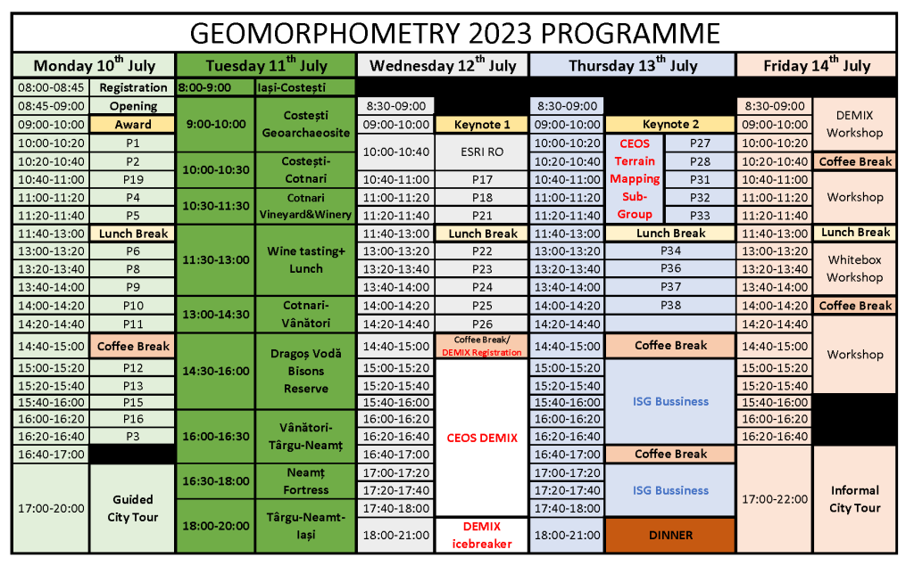
The presentation code from the paper list (available here) will show the slot from the programme above.
Monday (10th July) – Day 1 – voting
| 08:00-08:45 | Registration – front of Aula Magna Mihai Eminescu, University Main Corp (A) |
| 08:45-09:00 | Opening & Welcome Address – Aula Magna Mihai Eminescu, University Main Corp (A) |
| 09:00-10:00 | Geomorphometry Lifetime Achievement Award Lecture: John Wilson – “Recent Advances and Challenges in Geomorphometry“ |
| 10:00-10:20 | Ernest Fahrland, Virginia Herrera, Hanne Paschko and Henning Schrader – Evolution of the Copernicus DEM: beyond today’s elevation data with WorldDEM Neo |
| 10:20-10:40 | Laurence Paul Hawker, Peter Uhe and Jeffrey Neal – FABDEM Updates – FABDEM V1-2 |
| 10:40-11:00 | Peter Guth, Carlos Grohmann and Sebastiano Trevisani – Geomorphometric and Geospatial Patterns in Differences Between ALOS and COPDEM |
| 11:00-11:20 | Dean Gesch – Assessing Global Elevation Models for Mapping the Low Elevation Coastal Zone |
| 11:20-11:40 | Richard Feciskanin – DEM generalization using polygonal simplification |
| 11:40-13:00 | Lunch Break – Titu Maiorescu Canteen |
| 13:00-13:20 | Fei Zhao and Liyang Xiong – A novel algorithm for calculating flow direction in multi-lake areas |
| 13:20-13:40 | Sebastiano Trevisani and Peter L. Guth – Landscape according to surface roughness: experimenting in the Taklimakan Desert |
| 13:40-14:00 | Vincent Lecours, Benjamin Misiuk and Craig J. Brown – Exploring the Effects of Acoustic Frequency on Terrain Attributes and Classifications Derived from Digital Bathymetric Models at Multiple Scales |
| 14:00-14:20 | John Lindsay – The time-in-daylight land-surface parameter |
| 14:20-14:40 | Gaurav Sinha, Samantha Arundel, Romim Somadder, David Martin and Kevin McKeehan – Geomorphometric analysis of Summit and Ridge landforms in the USGS GNIS topographic database |
| 14:40-15:00 | Coffee Break – The Hall of the Lost Steps, University Main Corp (A) |
| 15:00-15:20 | Mihai Niculiță – Neighborhood contextual merging of segments for landform detection and classification |
| 15:20-15:40 | Andrei Dornik, Marinela Adriana Cheţan, Lucian Dragut, Andrei Iliuţă and Daniel Dorin Dicu – Delineation of mapping units for land suitability assessment using land-surface parameters |
| 15:40-16:00 | Janusz Godziek – Application of LiDAR-based DTMs and DSMs to detect landforms created by the trees uprooting process |
| 16:00-16:20 | Christian Depraetere, Benoît Deffontaines and Serge Riazanoff – Resampling and hydrogeomorphometrical processing of dense Lidar/DEM: Relationships between landforms and hydrological processes in a Mediterranean peri-alpine catchment basin |
| 16:20-16:40 | Maeve DeBuse and Peter Guth – Evaluation of elevation, slope, roughness, and vegetation type on the burn severity of the 2020 Calwood Fire in Boulder County, Colorado |
| 17:00-20:00 | Guided City Tour – Meeting point is Corp A entry |
Tuesday (11th July) – Day 2
08:00-20:00 Fieldtrip
| 8:00-9:00 | Travel from Iași to Costești |
| 9:00-10:00 | Costești Geoarchaeosite |
| 10:00-10:30 | Travel from Costești to Cotnari |
| 10:30-11:30 | Cotnari Vineyard & Winery |
| 11:30-13:00 | Wine tasting & Lunch |
| 13:00-14:30 | Travel from Cotnari to Vânători |
| 14:30-16:00 | Visit to Dragoș Vodă Bison Reserve |
| 16:00-16:30 | Travel from Vânători to Târgu Neamț |
| 16:30-18:00 | Neamț Fortress Visit |
| 18:00-20:00 | Travel from Târgu Neamț to Iași |
Wednesday (12th July) – Day 3 – voting
| 9:00-10:00 | Keynote Lecture 1: John Lindsay – The case for locally scale optimized land-surface parameters | |
| 10:00-10:40 | Simona Bacau – ESRI Romania – Processing Drone Imagery | |
| 10:40-11:00 | Bofei Zhao, Haigang Sui and Qiming Zhou – Flood inundation analysis based on SAR image and DEM: A case study of the 2021 Zhengzhou Flood in China | |
| 11:00-11:20 | Alexander Brenning – Novel approaches to spatial model assessment and interpretation: the example of landslide susceptibility modeling | |
| 11:20-11:40 | Nicusor Necula and Mihai Niculita – Machine learning classification of geomorphometric segments for floodplain detection and delineation | |
| 11:40-13:00 | Lunch Break – Titu Maiorescu | |
| 13:00-13:20 | Liyang Xiong, Jiang Yinghui and Sijin Li – Super-resolution for terrain modeling using deep learning in High Mountain Asia | |
| 13:20-13:40 | Yu-Feng Ho, Tomislav Hengl and Leandro Parente – Cloud services for ensemble global elevation data using an updatable method achieved by parallel computation | |
| 13:40-14:00 | Jun Chen, Liyang Xiong, Guanghui Hu and Guoan Tang – Integrating topographic knowledge into point cloud simplification for terrain modelling | |
| 14:00-14:20 | Juan Francisco Reinoso-Gordo and Francisco Javier Ariza-López – A method to rank global DEMs quality focused on their horizontal accuracy | |
| 14:20-14:40 | Adam Rusinko and Jozef Minár – The role of geomorphometric predictors in LUCC modeling | |
| 14:40-15:00 | Coffee Break – The Hall of the Lost Steps, University Main Corp (A) | |
| CEOS DEMIX | ||
| 15:00-15:20 | Peter Strobl – Overview of the DEMIX Initiative | |
| 15:20-15:40 | Carlos Henrique Grohmann, Carlos López-Vázquez, Peter Guth, Conrad Bielski – The DEMIX Wine Contest: a summary | |
| 15:40-16:00 | Carlos Henrique Grohmann – The DEMIX Wine Contest Jupyter notebook | |
| 16:00-16:20 | Peter Guth, Carlos Henrique Grohmann and Sebastiano Trevisani – Subjective Criterion for the DEMIX Wine Contest: Hillshade Maps | |
| 16:20-16:40 | Guth, Peter L, Grohmann, Carlos H., Trevisani, Sebastiano, & Bielski, Conrad – Going Forward: Extending and Exploiting the DEMIX Database With MICRODEM | |
| 16:40-17:00 | Serge Riazanoff – DEMIX SG3 “Platforms & Processing” studies – Quality assessment of global DEMs from LiDAR data, planimetric, misregistration assessment, use of VHR DEMs to produce Sentinel-1 ARD | |
| 17:00-17:40 | Panel discussions with the audience | |
Thursday (13th July) – Day 4 – voting
| 09:00-10:00 | Keynote Lecture 2: Jozef Minar – “Using principles of physics in geomorphometry: moving toward hypothetico-deductive geoscience“ | ||
| 10:00-10:20 | CEOS Terrain Mapping Sub-Group | Xiaohui Huang and Liyang Xiong – Mapping gully affected areas based on Sentinel 2 imagery and digital elevation model | |
| 10:20-10:40 | Tian Jia, Cheng-Zhi Qin, Ping Fu and Vladimir Brusic – Applicability of longitudinal profiles for glacial cirque classification | ||
| 10:40-11:00 | Ian Evans, Yingkui Li and Zhibin Zhao – Dependence of statistical results on definitions and extents of study area: examples from cirques and glaciers | ||
| 11:00-11:20 | Hannes Reuter – Applying Terrain analysis to human population? | ||
| 11:20-11:40 | Francisco Javier Ariza-López and Juan Francisco Reinoso – Functional Quality for GDEMs Assessment | ||
| 11:40-13:00 | Lunch Break – Titu Maiorescu | ||
| 13:00-13:20 | Francisco Javier Ariza-López, Manuel A. Ureña-Camara, Juan Francisco Reinoso and Marcelo Antonio Nero – Proposal for a Collaborative Data Infrastructure for Control of DEMs | ||
| 13:20-13:40 | Guohua Gou, Haigang Sui, Sheng Wang, Qiming Zhou and Jianya Gong – Constructing a True 3-D Model of a Karst Cave Using an UAV | ||
| 13:40-14:00 | Carlos Grohmann, Gulherme Garcia, Camila Viana, Helen Dias and Rebeca Coelho – RPA flight pattern and GCP influence on SfM-MVS modeling of a stable landslide in SE Brazil | ||
| 14:00-14:20 | Haigang Sui, Hao Zhang, Qiming Zhou and Jianya Gong – The true 3-D surface reconstruction using a multi-UAV cooperation method | ||
| 14:20-14:40 | ISG Busssiness Meeting | ||
| 14:40-15:00 | Coffee Break – The Hall of the Lost Steps, University Main Corp (A) | ||
| 15:00-15:20 | ISG Busssiness Meeting | ||
| 15:20-15:40 | ISG Busssiness Meeting | ||
| 15:40-16:40 | ISG Busssiness Meeting | ||
| 16:40-17:00 | Coffee Break – The Hall of the Lost Steps, University Main Corp (A) | ||
| 17:00-18:00 | ISG Busssiness Meeting | ||
| 18:00-21:00 | Dinner – University House | ||
Friday (14th July) – Day 5
| 8:45-10:20 | Serge Riazanoff – DEMIX workshop – Department of Geography, University Corp B (1) VtWeb for DEMs and (2) DEMIX Operations Portal (1) How to use VtWeb to select DEMs, their various versions, visualise them, apply on-the-fly processing, compare interactively DEMs and their versions, compute statistics, compute profiles… See for example https://visioterra.fr/telechargement/A003_VISIOTERRA_COMMUNICATION/HYP-107-VtWeb-E_Comparison_of_Copernicus_DEM_releases_2022_vs_2021.pdf (2) How to use “DEMIX Operations Portal” to import candidate and VHR reference DEMs and to compute criteria. See https://visioterra.org/DemixOperationsPlatform/ |
| 10:20-10:40 | Coffee Break – Department of Geography, University Corp B |
| 10:40-11:40 | Serge Riazanoff – DEMIX workshop – Department of Geography, University Corp B DEM4S2 How to get the DEM that has been used to orthorectify the Sentinel-2 tile and how this DEM produced on the exact tile footprint can be uploaded to better photo-interpret the optical data. See for example https://visioterra.org/DEM4S2/?s2Id=S2A_MSIL1C_20230616T012701_N0509_R074_T54STE_20230616T045503 |
| 11:40-13:00 | Lunch Break – Titu Maiorescu |
| 13:00-14:00 | John Lindsay – Whitebox Workshop – Department of Geography, University Corp B |
| 14:00-14:20 | Coffee Break – Department of Geography, University Corp B |
| 14:20-15:40 | John Lindsay – Whitebox Workshop – Department of Geography, University Corp B |
| 15:40-17:00 | John Lindsay – Whitebox Workshop – Department of Geography, University Corp B |
| 17:00-22:00 | Informal City Tour |