The main objective of the project is to develop a methodology for assessing the physical and socio-economic vulnerability for a sustainable expansion of the territory in areas with a low risk of occurrence of natural hazards.
In this respect, the specific objectives of the project are:
- Spatial estimation of the susceptibility of the land to the triggering of natural hazards (flash floods, floods, landslides and earthquakes).
- General hazard map
- Vulnerability assessment of settlements
- Identifying social vulnerability
- Risk mapping by integrating results on land susceptibility with social vulnerability;
- Proposing the measures needed for vulnerable communities to increase resilience.
The innovative aspects in the project's implementation of objectives and activities are associated with the comprehensive analysis achieved by integrating terrain susceptibility to natural hazards with the socio-economic vulnerability of the population at the level of the administrative-territorial units in the North-East Development Region
📜 Final research report
The requirement for natural hazard studies results from the necessity to minimise impacts on communities. Uncontrolled spatial sprawl, chaotic distribution of buildings, lack of a coherent spatial development policy, absence of a substantiated and validated risk study, make it necessary to study these aspects for efficient risk management.
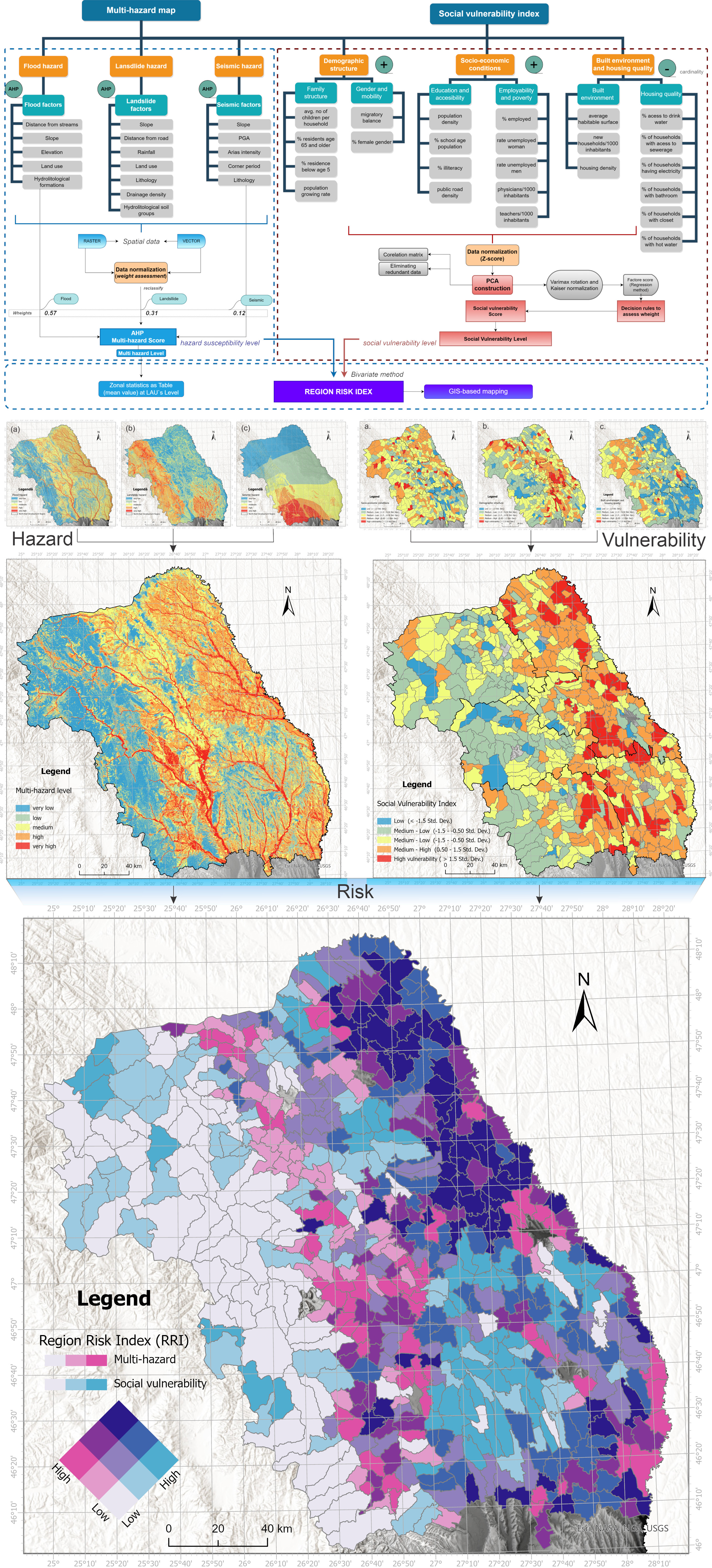
The map on the terrain susceptibility to natural hazards highlights the most vulnerable areas are distributed along the hydrographic network (10.25% of the total area). The most vulnerable area being at the contact between the mountain and plateau area, on the Moldavian Subcarpathians alignment, as well as the confluence area between the main hydrographic rivers.
According to the social vulnerability map, it can be seen that the counties in the eastern part of the region are more vulnerable (Botoșani, Iași and Vaslui). At the level of the North-East Region, 60 LAUs were identified, representing 10.86% with high vulnerability. 27.35% of the LAUs analysed are included in the medium-high vulnerability category, most of them being distributed in the eastern part of the region (Figure 15a). The LAUs with SoVI values included in the medium and low-medium vulnerability class (33.96% and 27.53%, respectively) are generally clustered in the western part of the region, overlapping the mountainous area and the contact zone.
The intersection between geo-hazards and social vulnerability was performed using bivariate assessment that identifies hotspots: areas with high levels of hazard and at the same time high levels of social vulnerability. Thus, nine classes were obtained by combining the two datasets. The use of the bivariate colorimetric approach reveals a critical correlation factor where the LAUs with high social vulnerability and high hazard susceptibility imply an alarming situation. This complex interplay of factors highlights areas that require major attention from the authorities. From the final analysis of natural hazard risk it can be seen that 10.68% of the LAUs in the study area are in the high-high class and show a predominantly north-eastern distribution (Figure 16). The very high social vulnerability is due to the fact that within these LAUs the population density is high, the area is predominantly rural, with limited access to education, utilities and low employability, exposed to natural hazards.
The results obtained from this study represent an important contribution to land use planning by integrating risk categories that generate particular problems for anthropised areas. Expanding these areas to zones where natural hazards occur frequently without adequate spatial planning leads to events that affect local communities.
Published articles:
ISI articles
- Chelariu, O.E., Minea, I., Iațu, C. 2023. Geo-hazards assessment and land suitability estimation for spatial planning using multi-criteria analysis. Heliyon, 9(7), https://doi.org/10.1016/j.heliyon.2023.e18159. IF: 4, AIS: 0.607.
- Chelariu, O.E., Iațu, C., Minea, I. 2022. A GIS-Based Model for Flood Shelter Locations and Pedestrian Evacuation Scenarios in a Rural Mountain Catchment in Romania. Water, 14(19), 3074, https://doi.org/10.3390/w14193074. IF: 3.4, AIS: 0.517.
In review process
- Chelariu, O.E., Minea I., Iațu C. 2023. Integrated assessment of geophysical and social vulnerability to natural hazards in North-East Development Region, Romania. Geomatics, Natural Hazards and Risk (in review process) IF: 4.2, AIS: 0.773.
- Minea I, Chelariu, O.E., Boicu D. Iosub M. 2023. Assessing the social vulnerability associated to groundwater resources in temperate climatic conditions. Applied Water Sciences (in review process). IF: 5.5; 0.741.
Awards
- Best Paper Award for oral communication at 2nd Mediterranean Geosciences Union Annual Meeting (MedGU – 22), held in Marrakech, on 27-30 November 2022 pentru lucrarea A multi-hazard approach regarding territorial development suitability in North-East Region, Romania, authors – Chelariu Oana-Elena, Iațu Corneliu, Minea Ionuț.
- Best Paper Award for oral communication at 5th Euro-Mediterranean Conference for Environmental Integration (EMCEI-23), 2-5 October 2023, Rende, Italy pentru lucrarea A GIS-based approach to identify the spatial variability of social vulnerability in North-East Region, Romania, authors – Chelariu Oana-Elena, Iațu Corneliu.
Participation in conferences:
International conferences
- Istanbul, 26 – 30 noiembrie 2023, Mediterranean Geosciences Union – MedGU-23 cu lucrarea The assessment of socio-economic vulnerability in a multi-hazard concept in the North-East Region of Romania, autori: Chelariu Oana-Elena, Iațu Corneliu.
- Rende (Cosenza), 2 – 5 octombrie (on-line) 5th Euro-Mediterranean Conference for Environmental Integration cu lucrarea : A GIS-based approach to identify the spatial variability of social vulnerability in North-East Region, Romania, autori: Chelariu Oana-Elena, Iațu Corneliu.
- Skopje, 8-9 mai 2023, Geobalcanica 2023 cu lucrarea An approach for measuring social vulnerability in a multi-hazard context, autori Chelariu Oana-Elena, Iațu Corneliu, Minea Ionuț.
- Marrakech, 27-30 noiembrie 2022, Mediterranean Geosciences Union, MedGU, ediția a II-a cu lucrarea: A multi-hazard approach regarding territorial development suitability in North-East Region, Romania, autori: Chelariu Oana-Elena, Iațu Corneliu, Minea Ionuț.
Scientific conferences in Romania
- București, 17-18 noiembrie 2023, INTERNATIONAL CONFERENCE Environment at CrossrOads: SMART approaches for a sustainable future – ECOSMART cu lucrarea Groundwater resources in Eastern Romania between climate changes impact and social vulnerability (PP), autori: Minea Ionuț, Iosub Marina, Chelariu Oana-Elena, Boicu Daniel.
- Iași, 27-29 octombrie 2023, Lucrările Seminarului Geografic Internațional "Dimitrie Cantemir", Editia a 43 cu lucrarea: Integrated assessment of geophysical and social vulnerability to natural hazards in North-East Region, Romania, autori: Chelariu Oana-Elena, Iațu Corneliu, Minea Ionuț.
- Iași, 28 octombrie 2023, Simpozionul Științific Național cu participare internațională ”Mircea Savul” cu lucrarea An integrated GIS-based approach for geohazards risk assessment. Autori: Chelariu Oana-Elena, Minea Ionuț.
- Iași, 9-10 iunie 2023, International Conference Present Environment and Sustainable Development, XVIII-th Edition, Iași cu lucrarea: Social vulnerability to natural hazards in North-East Region of Romania, autori: Chelariu Oana-Elena, Iațu Corneliu, Minea Ionuț.
- Cluj-Napoca, 17-19 martie 2023, The International Conference Air and Water – components of the environment, 15th edition cu lucrarea: Vulnerability of human settlements and economic activities to natural hazards in the North-East Region, Romania, autori: Chelariu Oana-Elena, Iațu Corneliu, Minea Ionuț.
- Iași, 3-4 iunie 2022, 17th edition of the International Symposium "Present Environment and Sustainable Development" cu lucrarea: GIS-based multi-criteria analysis for flood prone areas and suitability estimation for urban planning in North-East Region of Romania, autori Chelariu Oana-Elena, Corneliu Iațu.
- Iași, 3-4 iunie 2022, 17th edition of the International Symposium "Present Environment and Sustainable Development" cu lucrarea: An approach for assessing social vulnerability related to groundwater resources at local level in North Eastern part of Romania, autori: Oana-Elena Chelariu, Ionuț Minea, Daniel Boicu și Marina Iosub.
- Iași, 14-16 octombrie 2022, Lucrările Seminarului Geografic Internațional” Dimitrie Cantemir” Ediția a XLII-a cu lucrarea: Multi-hazard assessment modeling using multi-critera analysis and GIS: a case study, autori: Chelariu Oana-Elena, Iațu Corneliu, Minea Ionuț
Project Leader: university assistant PhD Oana-Elena HAPCIUC (CHELARIU)
e-mail: oana.chelariu(a)uaic.ro
https://orcid.org/0000-0003-4468-0688